The Mount Diablo Surveyors Historical Society
Three Monuments, One Initial Point
(The Story of The San Bernardino Initial Point Monument)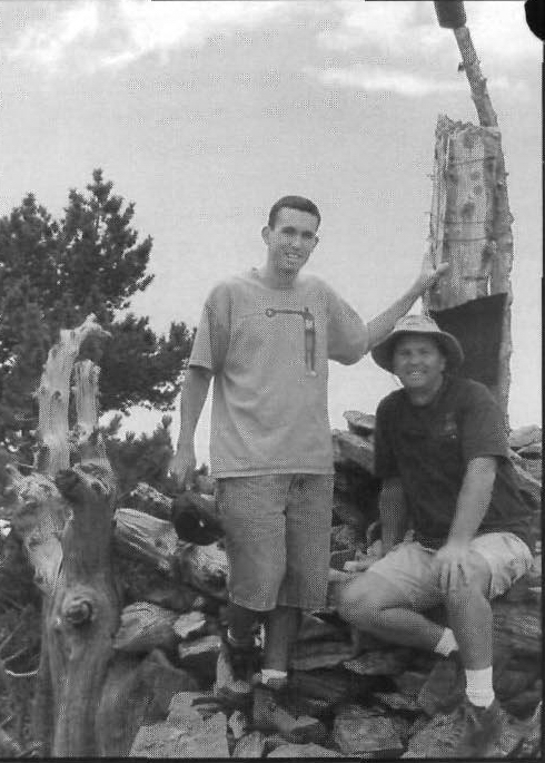 By Michael A. Duffy, PLS
On November 7th, 1852, Colonel Henry Washington, Deputy Surveyor under contract
with the United States Surveyor General of California, completed a four day hike with 12
men to a point he designated and monumented to be the Initial Point for all future
cadastral surveys in southern California. This November will mark the Sesquicentennial
(150 year anniversary) of the establishment of the Washington Monument Initial Point.
Washington describes the journey to his Initial Point that day in his letter dated December
1852 to Samuel D. King, then the Surveyor General of California,
“The men being much fatigued did not perform much service until the next day. The
travel over mountain spurs being very laborious.”
The work was so difficult that Washington’s letter contains a wordy paragraph partially
reprinted below hoping to persuade the government to feel sorry for him because he
underbid the job. This was probably the first surveyor in California that made this
mistake, but we all know it would not be the last.
“The amount of my account for expenses incurred in erecting the monument being close
to $511.00 was forwarded to you on the 5th instruction, but although this account closes
the transaction, with the Government, it is nevertheless proper to state that it does not
cover all of my necessary expenses… and the opinion expressed by you that Four
Hundred Dollars was enough to cover all necessary expenditures upon this work,
believing as I do, that the account for the above reasons, would not be allowed, or, if
allowed, greatly delayed to the prejudice of the public service.”
Little did Colonel Washington know that his monument would soon become the point of
beginning of every piece of private and public property owned by the now 25 million
inhabitants of southern California. Nestled at an elevation of 10,300 feet just west of what
is now know as Mount San Bernardino, this Initial Point is both the highest and hardest to
reach in the entire country. According to surveyor C. Albert White, in his book entitled,
“Initial Points of the Rectangular Survey System”, it is also the only one that has not been
altered over time by man. And, to add to its mystique, this point has one other unusual
characteristic feature that makes it that much more unique – it is not alone.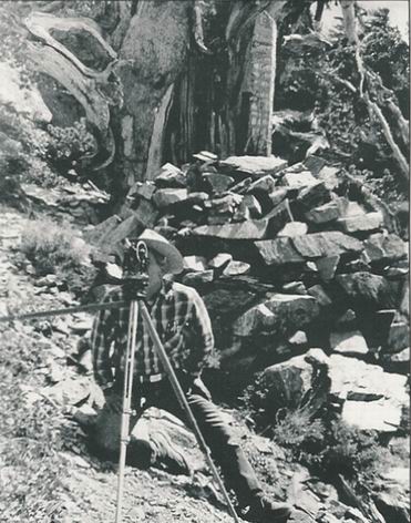 The work was not only difficult; it also had its dangers as indicated by Washington’s
records of this time period. They are full of interesting insights and comments on the
dangers of surveying in the 1850’s in southern California. In couple portions of his notes
read,
“From the last corner a deserted adobe house bears S 2° 15’ East. A man named Moore
is said to have been one of the original occupants, but driven off by the Indians.”
“From the last corner it is S 41° E, about 2 ¼ miles (can see the smoke but the camps are
hidden from the view by a range of hills, near the village) to an Indian Village.”
Washington did not travel blindly into this survey assignment. King had sent Leander
Ransom, the surveyor who had established the first Initial Point in California at Mt.
Diablo the year before, ahead of Washington by a few months.
His job was to recon and
select an appropriate location for the monument on a high point that would allow the
southerly meridian to intersect the Mexico border before striking the Pacific Ocean. His
description of the native Indians was a bit more docile than Washington’s,
“On our trip we saw several groups of Indians, some on horseback, and some on foot,
some with bows and arrows, and some with nothing but a jug of whiskey.”
By definition an Initial Point is singular, finite, unique, one of a kind. An Initial Point
normally establishes the base and meridian lines as defined by the United States
Rectangular System for the orderly subdivision of land for a defined region. It officially
marks the intersection of two lines extending out to the north, south, east and west as far
as is necessary to reach the boundary of the next base and meridian. By a series of
strange circumstances, covering a period of over 55 years after Washington’s first survey,
the San Bernardino Base and Meridian has the dubious honor of three possible initial
points.
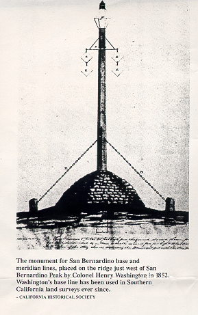
Washington describes his monument he constructed in great detail clearly planning on
observing it from the valley below at a latter date. “The monument formed of 2 pieces of
timber spliced and braced by 3 iron bands, 25 feet 9 inches long extending from the
surface of the earth 23 feet 9 inches long hewed from the surface 8 x 10 inches on 4 sides
to the distance of 13 feet and remainder tapering off to top 4 inches in diameter.” An
eight-foot portion of the original post and the entire rock mound remains in good
condition today. Washington continues by describing the condition of the sighting tins
supplied to him by the Surveyor General’s Office, “Before leaving the grounds the tins
attached to the cross bars have fallen down, with the exception of one and there being no
swivels at hand it was found impossible to fasten them in such a way as to stand the
heavy blows. I therefore had them securely fastened to the monument.” I add this detail
of the tins because several of them have been recovered at the site between 1988 and
2001 (See Washington’s Diagram of his Initial Point Monument).
 Washington also made
10 observations that day to distant objects from the Initial point that day, which included
two large structures,
“9 – S 75° 35’W To old Mission Bldg., approximate distance 20 miles”
“10 – S 87° 05’W To Mormon Fort, approximate distance 23 ½ miles”
The story behind the three monuments begins with the final sentence in Washington’s
letter to Mr. King. Washington closes his letter to the Surveyor General by stating,
“The San Bernardino Mountain about the monument was considered too rugged to
attempt the survey of the Base and Meridian Lines from that point. Satisfied that the line
could not have been measured with the requisite degree of accuracy.”
The saga picks up again eight days later in Washington’s government notes dated
November 17th, 1852 with Washington beginning a traverse from his ‘Point of
Beginning’, in what is now the City of Yucaipa. He records in his notes a bearing of
South 45° West for his Point of Beginning from the Initial Point but gives no distance call
(see the George Johnson Plat). He goes on to state that the Initial Point is plainly visible
from the valley on that day. His random traverse then proceeds on courses called out as
due North, South, East and West bearings for a distance of over 12 linear miles until he
makes the statement,
“…set a stake from which the monument on the top of San Bernardino Mountain
established on the 8th of November, 1852 bears due East, and the true distance, as
ascertained by the foregoing lines shows it to be 13 miles, 9 chains, 80 links.”
Washington then goes on to traverse due East along the San Bernardino Baseline ‘1 mile,
9 chains, 80 links’ to the Township corner for Ranges 2 and 3 West. From this point
Washington begins his township surveys of that area that evidentially returns him to the
‘yet to be established’ Meridian Line 12 miles south of his Initial Point.
In a report dated 1967 entitled “Washington Monument Resurvey Expedition” written by
Mr. Bill D. Laurie for the San Bernardino County Museum, Mr. Laurie concludes that,
“To date, no record has been found which would indicate Washington’s methods or
procedures for surveying away from his initial point.” This missing piece of the puzzle
or, as the radio announcer Paul Harvey might say, ‘the rest of the story’ regarding
Washington’s establishment of the San Bernardino Base and Meridian has still never
been completely solved, though Mr. White has the most developed explanation in print.
So I am challenged in this brief article to propose what I believe to be Colonel
Washington’s methodology for establishing the San Bernardino Base and Meridian
without ever measuring from the Initial Point itself. I will also pose a challenge to the
reasoning (as does Mr. White) behind the United States Government Land Office in
accepting the rejection of Washington’s corner twice, in the span of 55 years, after it was
established. This despite the fact that the Washington Monument was never reported
destroyed and was found by all subsequent surveyors in the area.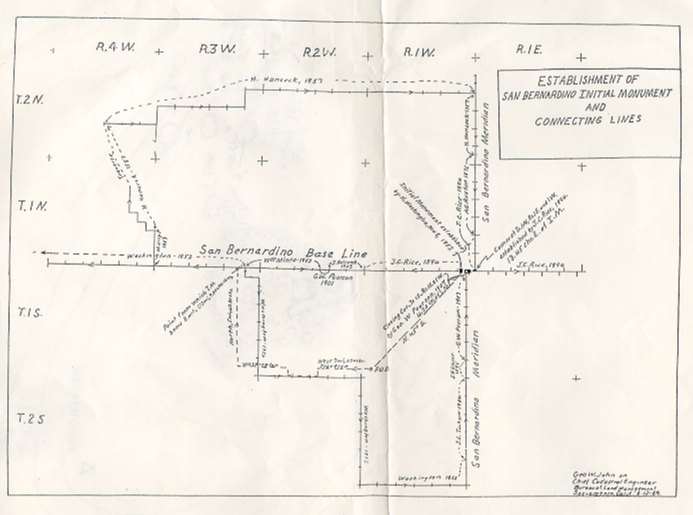 George Johnson, a Cadastral Engineer for the Bureau of Land Management (BLM)
produced a map in 1969 that summarizes the remaining government surveys necessary to
complete the townships in the vicinity of Washington’s Initial Point. The BLM can find
no text to accompany this diagram to date, but it is very similar to Mr. White’s summary
in his chapter on the San Bernardino Initial Point.
Johnson’s map shows Henry Hancock, Deputy Surveyor running a series of township
boundaries and traverses between the years of 1853 to 1857 that would return him to the
Meridian Line 10 miles north of the Initial Point. Hancock’s surveys covered over 34
linear miles. However, it would not be until 1894 that John C. Rice would finally
complete the Meridian Line to the Initial Point from the north. And this is when the fun
truly begins. Rice’s notes describe him meeting the Baseline and finding Washington’s
monument 13.45 chains (887 feet) to the West. It is then that Rice decides to set a new
Initial Point, which he does, in much the same fashion as Washington did 42 years before
him using a huge mound of stones and a large hewed post with scribing. He then runs the
Baseline the final six miles to the West calling Washington’s monument off line
southerly by 4 feet as he goes by it.
In similar fashion, George W. Pearson completes the Meridian Line from the south in
1907 and again finds both Washington and Rice’s monuments intact. He decides to set a
third point as a closing corner from the south, the monument being a large stone with
chiseled markings, to Rice’s Baseline and the last of the three Initial Points is born.
Pearson’s monument falls 610 feet east of Washington’s monument and 277 feet west of
Rice’s monument (see Three Monument Diagram).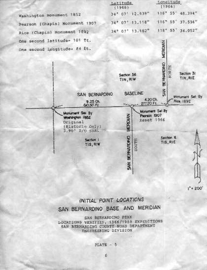
The combined distances of the surveys needed to bring the north and south Meridian lines
back to the Initial Point area is over 94 miles including Washington’s initial traverse out
of Yucaipa to his new Baseline. Questions abound as to where the errors were made to
have the misclosures of nearly 900 feet in the northern townships and over 600 feet in the
southern townships. Also critical to the analysis is discovering how Washington got
down off the mountain, which is what I hope to describe first.
Washington knew all along that he would never be able to traverse his way off San
Bernardino Mountain in time to produce Base and Meridian Lines needed to begin
township surveys of the southern part of this promising new state, now only two years
old. The idea for a tall post with reflectors had already been conceived in the Surveyor
General’s Office in San Francisco where the tin reflectors were manufactured.
Washington’s plan, that obviously included Ransom and King, was to set a tall enough
post in an area that could be seen from at least two places from the valley below, one of
which would be on the Baseline. We know from his notes he changed his plans to set the
Initial Point on the very top of San Bernardino Mountain because he writes to the
Surveyor General of the numerous trees on that peak. So he moves the point to a bald
ridge area about ½ mile west of the top for better visibility.
Washington randomly placed himself on a 45° angle from the Initial Point by use a solar
compass to establish astronomic north and then wiggling in on this line. He then
traversed in one-mile intervals, avoiding any physical obstacles such as the Crafton Hills,
until he got close to the Baseline. He would then need to again wiggle along a true north
line until he could site the Initial Point again and find it to be due East of his position.
Washington would then only have to add up the latitudes and departures of his traverse to
establish two sides of the rectangle he constructed. With the two angles he had measured
to the Initial Point, Washington would have created a simple trapezoid figure made up of
rectangle and right triangle. Knowing the relationship of the sides of a right isosceles
triangle (1,1,√2) he could have obtained his distance west of the Initial Point by adding
the sum of one long side of a rectangle and one side of his right triangle (see Mr. C.
Albert White's diagram). 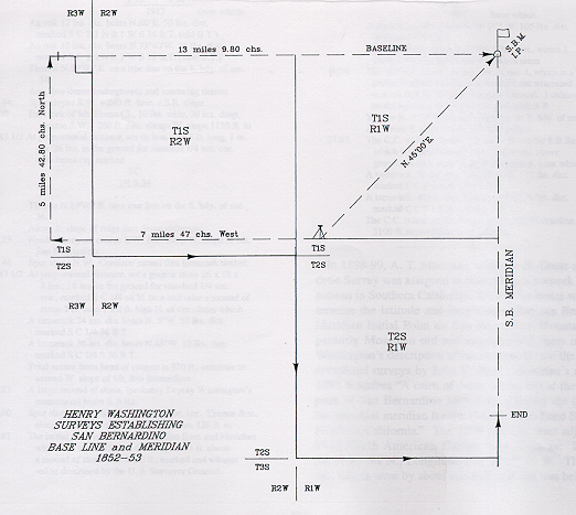 No higher mathematics was necessary. Washington hints at a
simple mathematical solution when he states in his notes,
“…the monument on the top of San Bernardino Mountain established on the 8th of
November, 1852 bears due East, and the true distance, as ascertained by the foregoing
lines shows it to be 13 miles, 9 chains, 80 links.”
How accurate could Washington positioned his Initial Point with this methodology?
Quite accurate if he could see the monument clearly and he had no major errors in his 12-
mile traverse. A two-minute error in either angle he turned to his Initial Point would
have resulted in only a 40-foot error at most. A good sign that Washington did not make
an error greater than this comes from his own notes of his establishment of the south line
of Township 2 South, Range 1 West in late November 1852. When he measured to what
should have been the meridian line he states,
“Set temporary post - unable to see San Bernardino mountain there being a very high
range of mountains about 5 miles to the North. Went southward to a high hill and then
found the meridian from the monument to run 60 links (40 feet) East of the temporary
post.”
It is more likely that one could find an error in Hancock’s open-ended traverse that
covered 34 miles, including an elevation change of nearly 3000 feet through Waterman
Canyon. This appears to be the case when one studies his notes of 1857 carefully. As
Hancock approaches the meridian line ten miles north of the Initial Point his last section
is 90 chains long. But how did he "ascertain" this? Could he see the Initial Point five
years after it was constructed? His notes do not say. Upon further research and profile
analysis of the ground between Fawnskin, where Hancock established the meridian to the
north, and the Initial Point it does appear that Hancock did sight Washington's monument
to position himself longitudinally.
My final questions concern John C. Rice. Why did Rice establish his own point in 1892?
Why did he call Washington’s monument an ” old temporary monument established by
Deputy Washington in 1852”? Why is Rice’s last half mile 43.53 chain if he planned to
establish his own local Initial Point and Baseline? White’s conclusion that Rice’s
monument should be treated as a closing corner seems difficult to accept because Rice
had no line to close against, being nearly 900 feet east of Washington’s Initial Point.
I agree with Mr. White’s conclusion that “there is only ONE Initial Point and that is the
monument constructed by Henry Washington in 1852.” But I believe this should be
officially documented by the BLM. I also believe the BLM should produce a new plat
and notes showing some resolution of this interesting survey problem to re-establish the
Washington’s Monument as the true Initial Point. GPS measurements are planned to be
taken by the author of the monuments established by Washington and Hancock in the
1850's. These measurements will be taken on the Baseline east and west of his Initial
Point, and north and south on the Meridians this summer to help complete a more
thorough investigation of their relationship to Washington's Monument.
With the 150th anniversary fast approaching, the San Bernardino Mountain
Sesquicentennial Anniversary Committee is sponsoring an anniversary hike on October
12th, 2002 with the BLM, which will be filmed and documented, to commemorate
Washington’s important historical achievement. On November 9th, 2002 the day
Washington came down off the mountain, there will be a picnic at the Yucaipa Regional
Park from 10:00 am to 4:00 pm. The celebration will include speakers, historical
presentations, survey contests, games, a fishing tournament, exhibitions and lunch to
celebrate the event with a larger, more diverse audience.
White, C. Albert. 1996. Initial Points of the Rectangular Survey System, Westminster: The Publishing House, Colorado Word Works Inc.
[The foregoing article was first published in the September 2002 Issue #135 of the
California Surveyor and is reprinted here by permission of the Author.]
MDSHS - Mount Diablo Surveyors Historical Society
A California non-profit corporation organized under
IRS 501(c)3 (Federal #89116806802, CA 1835904).
Website designed and maintained by Michael J. Foley.
Page last updated: October 26, 2013
Copyright ©2005, 2013 MDSHS.
http://www.mdshs.org